Route 3
Santa Cruz - Bailadero - Pico del Inglés - Las Mercedes - La Cuesta - Santa Cruz
Technical information
- Start: Santa Cruz. TF-11.
- Finish: Santa Cruz. Plaza de España.
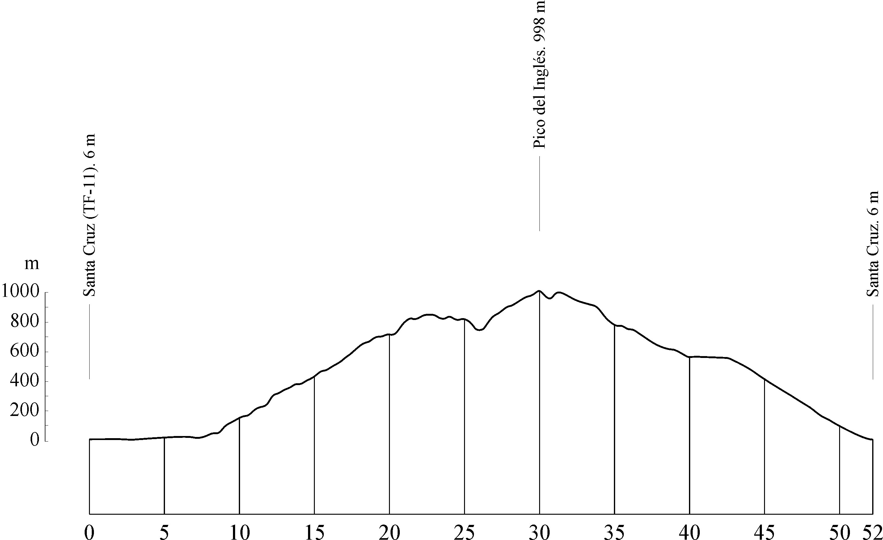
- Distance: 52 km (32.3 miles).
- Cumulative ascent: 1,235 m (4,051 ft).
- Average gradient: 4.9%.
- Maximum altitude: 998 m (3,274 ft).
- Average speed: 20 kph (12.42 mph).
- Estimated duration: 2 hours 35 mins.
- Difficulty level: Intermediate.
Route 3 is one of the most popular cycling routes around the capital. It is a round trip with a typical ascent and descent profile from a low point up to a high altitude and back down again. With a distance of 52 km (32.3 miles), it journeys through the north-west of the Island.
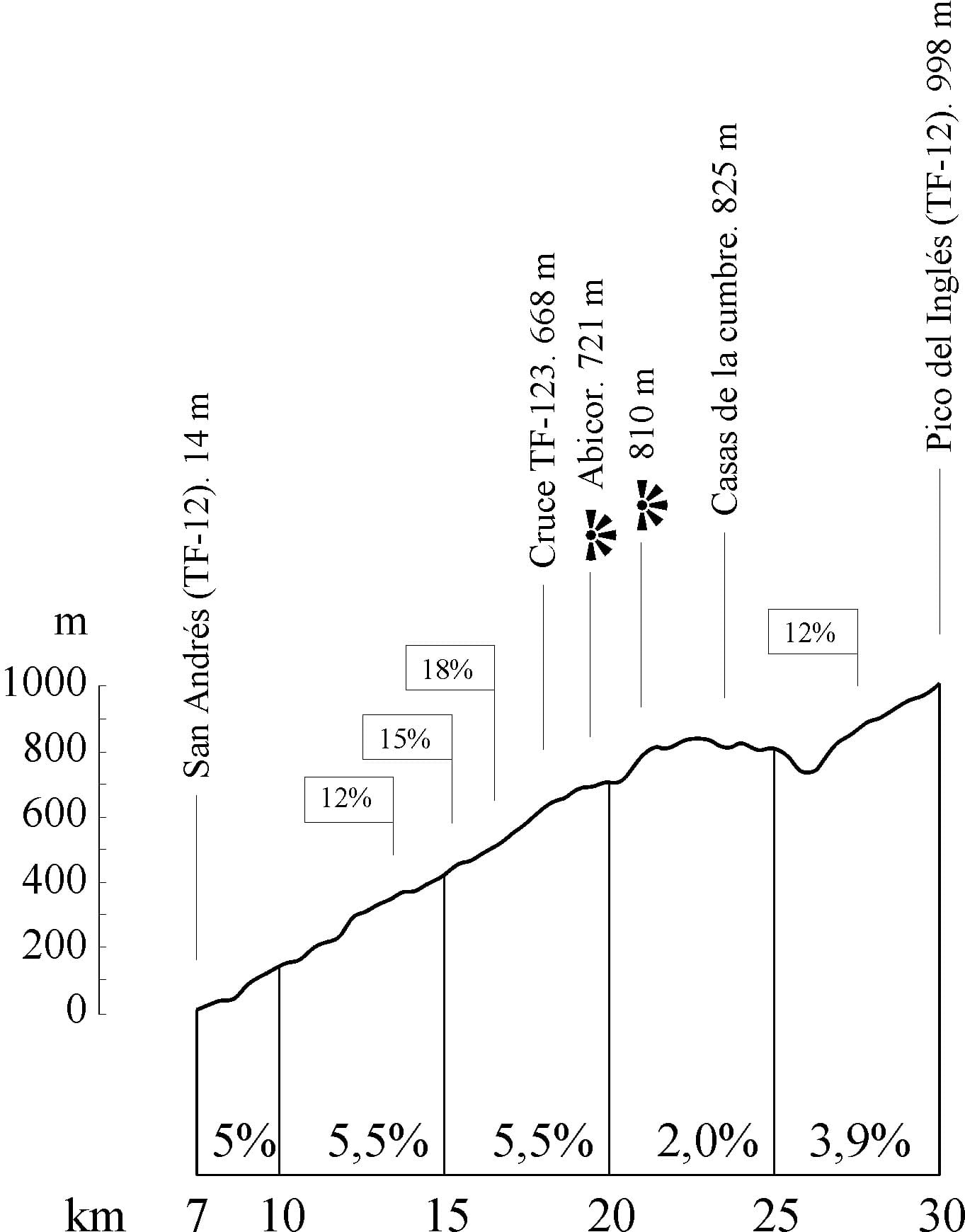
The journey begins in Santa Cruz at Avenida Marítima and then takes the TF-11, a flat dual carriageway where you will be able to pick up some speed. The coast will be right beside you. You will pass the docks and cranes of the Port of Santa Cruz. Stay on the TF-11 until you come to the fishing village of San Andrés, at km 7 (mile 4.3). Here, turn left towards the mountains along the TF-12 road.
The ascent begins as soon as you turn, with gentle slopes that get gradually steeper. You will notice the road getting windier as you climb. After cycling 18 km (11 miles), you will come to a crossroads where the TF-12 meets the TF-123. Keep going straight on and follow the signs for Las Mercedes and La Laguna.
At km 19.7 (mile 12.2) you will be rewarded with fantastic views of the northern slopes of the Anaga mountain range from the Abicor lookout point. At km 21 (mile 13), you can take in the breathtaking views of the south side. Shortly after this lookout point, the road gives you some respite with a flat stretch and a descent to the village of Casas de la Cumbre. But don't get too comfortable – the slopes are soon back with a vengeance, with gradients of up to 11%. Once you overcome the steep climb, you will reach the Pico del Inglés lookout point at an altitude of 998 m (3,274 ft). From there, you can enjoy fantastic views of Santa Cruz, Anaga, La Laguna and Mount Teide. This is the highest point on the route. Here begins the long descent through the laurel forests and back to urban areas, through La Laguna and Santa Cruz.
During your descent from Pico del Inglés, stick to the TF-12 road. You should be heading towards Las Mercedes and La Laguna by following the signposts. At km 31 (mile 19.2), you will pass Cruz del Carmen, where you will find another lookout point overlooking the lowlands of La Laguna against the backdrop of Mount Teide. A similar view awaits you at the Lomo Alto lookout point, which you will find on a sharp bend at km 33.5 (mile 20.8).
After km 36 (mile 22.4), the downward slope becomes more gentle and brings you to the town of Las Mercedes. One kilometre further on, you will come to a roundabout. Veer left here towards La Laguna along the TF-13 road. Take the Camino de las Mercedes road at km 38.7 (mile 24), which is also known as Camino de las Peras. The street named Calle Tabares Cala will then lead you into the centre of La Laguna, where you should take Calle Herradores and Calle Calvo Sotelo until you reach Avenida de los Menceyes. Finally, cycle down the Carretera General towards Santa Cruz.
Brief hypsometry

Full hypsometry


